New Website Features: Positional Accuracy
Positional accuracy
Pleiades has always kept track of the spatial accuracy of the coordinates stored in our Location resources. Whereas modern map series and GIS datasets produced in and since the 20th century generally manage and report this information as part of a spatial metadata package at the map, series, or dataset level, Pleiades was designed to aggregate spatial data from multiple sources and to provide for continuous enhancement. Accordingly, we devised the Positional Accuracy Assessment (PAA) as a document type in which information about the source and method of collection for one or more spatial geometries could be captured, as well as a "horizontal accuracy" value (encompassing formal accuracy and precision) in meters +/-. Users of Pleiades have always been able to "drill down" from an individual Location page to the corresponding PAA, and the accuracy data has long been included in our JSON and "GIS Package" exports.
As of last week, users will see the "horizontal accuracy" data drawn from our PAAs used in two new ways on the website.
 Positional accuracy: on Location listings on Place pages
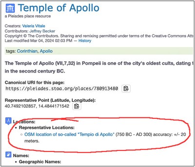
On each Place page, the "Locations" subheading introduces a summary list of all Location resources associated with that Place. These summaries now include the "horizontal accuracy" values in meters drawn from the corresponding PAA. Consider, for example, the Place page for the Temple of Apollo (VII,7,32) in Pompeii.
For those interested in the structure and details of Pleiades PAAs, here are some examples of widely used or exemplary ones:
- Dura-Europos Walls and Towers (Baird/Chen)
- Generic Handheld GPS
- Generic OSM Accuracy Assessment
- Google Earth and GeoEye Imagery 2016 and following
- Helsiniki Atlas
 Positional accuracy: on Maps on Place pages
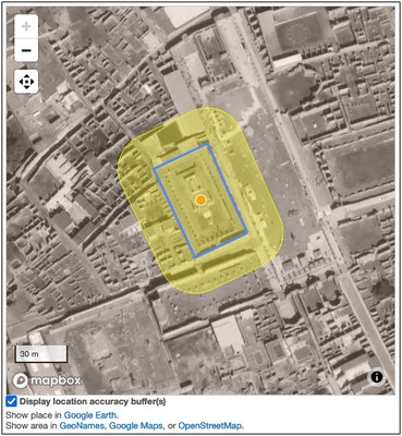
Maps on Pleiades Place pages now have a new feature permitting users to switch on or off location accuracy buffers around each Location geometry. When locations are shown in the Place page, a check box appears below the map labeled "display location accuracy buffers". By selecting (activating) this check box, the user will cause the map to add a yellow buffer around each Location, showing the relative extent of the footprint implied by the "horizontal accuracy" value in each corresponding PAA. Consider here the map for the same Place page discussed above.
This feature can be particularly useful when confronted with a Pleiades Place resource for which the available Locations still rely on coordinates digitized from small-to-medium-scale maps or when multiple Locations from different sources are presented. For example:
- Sevasto: a settlement site in Greece digitized from a Barrington Atlas map at 1:500,000 scale.
- Buddahs of Bamyan: coordinates sourced from a third-party service with presumed 2,000 meter accuracy.
- Nakoleia: a settlement site near modern Seyitgazi in Turkey for which three Locations are currently offerred: one digitized from a Barrington Atlas map, one digitized from a Tabula Imperii Byzantini map, and one digitized from high-resolution modern GIS data but only for the nearby, associated modern location rather than the archaeological site.

