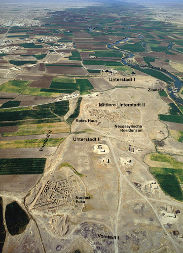
Imagery Location of Unterstadt I
a Pleiades
location
resource
Creators: Tom Elliott Copyright © The Contributors. Sharing and remixing permitted under terms of the Creative Commons Attribution 3.0 License (cc-by).
Creators: Tom Elliott Copyright © The Contributors. Sharing and remixing permitted under terms of the Creative Commons Attribution 3.0 License (cc-by).
Last modified
May 05, 2022 01:16 PM
—
History
Location of the earlier "lower city" settlement as determined in Google Earth with reference to annotated oblique aerial image published at schechhamad.de.
Show place in Google Earth.
Show area in GeoNames, Google Maps, or OpenStreetMap.
settlement
{ "type": "Point", "coordinates": [ 40.742064, 35.643094 ] }
Substantive
Certain
representative
- 2nd Millennium BCE (2000-1000 BCE) (confident)
- 1st Millennium BCE (1000-1 BCE) (confident)
- Roman, early Empire (30 BC-AD 300) (confident)
Pleiades